Posts in English

To read the blog in English, click here.

Posts en español

Para leer el blog en español, haz clic aquí.

Tuesday, November 3, 2015

The Other Side of Bolivia Part 2

Well, I'm back to continue the story of my time in the department (read: state) of Santa Cruz. 
First, a photo of the couple who hosted me in Santa Rita:

After our stay in the community of Santa Rita, we made the trek back to the city of Santa Cruz: six sweaty, sticky hours in a bus, where the breeze is life-saving but also barely tolerable because of the hot, humid air that it slams into your face. The initial bus ride to the town had been tolerable because I slept the whole way after staying up the night before (how did that become a tradition with my friends?) but this time no sleep was in reach. So when we arrived at the hotel in Santa Cruz, I ran straight for the pool and jumped straight in without even bothering to put a bathing suit on! What a relief! I proceeded to continue this trend every time that we returned to the hotel during the next two days spent in the city.

 Our time in the city was very short, and we barely got to know the central district before heading to our next destination. The city is organized in concentric rings, and only once did we leave the center of the innermost ring, so I wouldn't say that I know the city at all. But we did get to eat some tasty Japanese food - how happy was I to see kimchi on the menu! - and met someone who organizes a cycling movement of Santa Cruz. Oh, and we went to the first shopping mall of Bolivia, a trip that I did not enjoy because if you don't like shopping malls in the States, then you won't like them in Bolivia either. 

Our final stay was in the town of Samaipata, 3ish hours to the west of Santa Cruz, in the foothills of the Andes. The town has become a mecca for environmentally-conscious folk from around the world who are seeking a place to live out their ideals. There over 100 organic farms, countless permaculture and alternative therapy retreat centers, and lots of bioconstruction. At the same time though, there is still the local population that was there before the immigration began, and we got the sense that there is a fairly significant divide between the two populations. However, we really only interacted with the "immigrant" side while we were there, so I don't feel like I developed a very well-rounded perspective on the dynamics in the town. 

We were able to spend an entire day of our stay hiking in the national park that borders the town! This was an incredible experience because it is home to one of the world's few remaining Jurassic-era forests! Imagine yourself surrounded by giant ferns and 1,000 year old trees - pretty amazing!
Giant fern! They have trunks like trees but open up into a more normal-looking fern at the top.
Looking up the spiny trunk of one of the giant ferns.
The trunk of one of the anciant trees, in the eucalyptus family. They grow super slowly, thus look similar in size to a maple but are many times their age.
The yellow fruits on this plant are so poisonous that you will die if you eat them!

It was wonderful to get out in the mountains and hike for a day finally! And to have a biologist as a guide made it even better. Unfortunately the protected areas of Bolivia are protected by name but woefully underprotected in practice so there is infiltration in many of them by agriculturalists and loggers. Even during our hike, we came across a number of cows wandering through the brush, which is extremely damaging in such a fragile, unique environment. And just this year, President Evo Morales issued a decree that all protected areas can be opened for hydrocarbon exploration and extraction. So  even the "protected by name" element is losing it's significance! Our experience here in Bolivia has definitely shown us how empty  of meaning "official discourse" can be.


After a few more days of delicious food - so many fresh veggies! - and visits to various interesting initiatives, we headed back to Cochabamba. Now I'll be staying here until the end of the program! It's nice to know that for the whole month ahead I will be in one place, and on my own for the most part as we are about to start our independent research projects.

Next up: the story of my best and worst Halloween weekend.

Ciao,
Lucy


Bike Touring Scotland

After returning from Iceland in mid-August, I had a 10 day break from bike touring before heading up to Scotland with my old friend Will.

The plan was roughly 3 weeks cycling north along the West Coast and islands, starting in Glasgow. My photo-taking was a bit lax on this trip, so some days I simply didn't take any (worth posting). Consequently, I will do this one a bit differently: one long post with lots of pictures and not much text.

Here goes!

We cycled straight out of Glasgow on an NCN route, to the coast, where we caught a ferry to Arran. We cooked dinner outside Brodick castle, then camped in its woods. It rained heavily that night and the following morning, so we booked it north to the Mull of Kintyre (via a ferry onto the mainland). This is the view from our second night's camp site, on a high headland near Killberry

People warned us about the midges in Scotland. We thought we were prepared, with bug head nets and insect repellent. 

Sunset from our private headland on the Mull of Kintyre. Wild camping is legal in Scotland, but not all the places we wild-camped were ones where it was legal ;-)

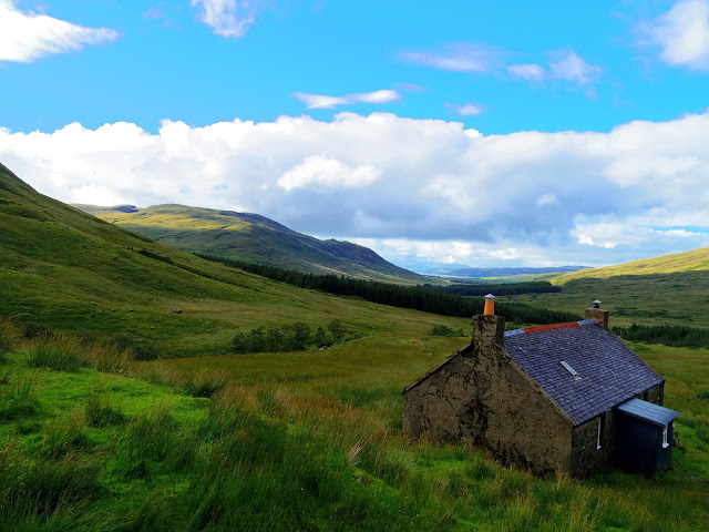
After Killberry, we spend two nights at Will's aunt Mary's house in Easedale, then biked to Oban, and took a ferry onto the isle of Mull. A half-day's cycle later, we got to Thomasleibhe, a bothy maintained for the free use of cyclists and walkers. 
Only 5 miles (and almost all rideable) from the road, it felt infinitely more isolated. We had the entire glacial valley and the basic but enjoyable accommodation of the bothy, completely to ourselves. It was so good we decided to eke out our food and stay two nights!  
The morning after arriving at Thomasleibhe, we hiked up the peak visible in the background of the previous photo, Beinn Taleidh. Unfortunately cloud swallowed the summit

Below the clouds. The bothy is just this side of the two tree plantations, from which we harvested several downed trees for the bothy's wood store.

Sunset on our second evening at Thomasleibhe. It was a beautiful sunny afternoon, which we spent mostly sat against the outside wall of the bothy, reading.

From Thomasleibhe we continued cycling north-west on Mull, through Salen, and then round the north coast of Mull, which was hilly, but pretty. This is Calgary beach, which was beautiful but the weather had turned cold. 
We reached Tobermory in the late afternoon, and then took a ferry to the almost-nonexistent town of Kilchoan, and began looking for a spot to camp. We found this, just a couple hundred yards from the road. Oh Scotland, how you spoil us!

The following morning was showery and chilly, so we stopped for an overpriced (but worth it?) cream tea. By lunch it had cleared a bit. This is the slipway at Salen (not the same Salen as the one on Mull).  Our aim for the evening was another bothy, called Peanmeanach, so we continued on with pretty riding along Loch Ailort.
 After spotting the turning for Peanmeanach, we struggled with the bikes down an unrideable path, before ditching them and continuing on with our panniers. After doing1 of 3.5 miles to the bothy, we gave up and camped here, right next to the shore. We had a chilly dip in the sea before dinner. That night we almost had a great mishap, as the site we originally pitched the tent flooded as the tide rose! Thankfully we had thought better of our original site, but the water was still only feet from the tent. 
In the morning we battled our way back uphill with bags and bikes -- tiring and frustrating. Then continued north against a strong headwind, past Arisaig, and had lunch at this spot, on the so-called "Silver Sands of Morar." From there, we headed a inland to Loch Morar 
We were in search of a headland on the north side of the Loch, described as being a couple hundred feet from the path, and a half-day's-walk-for-a-9-year-old beyond the end of the road. This was the very spot, about 50 years earlier, where my dad, aged 11, led his younger brothers Chris and Nick on their first independent camping trip! It was exactly as described, if a half-day's-walk-for-a-9-year-old is only about 500m!
As they had, we pitched the tent right up on the headland, with sweeping views of the loch. We washed our clothes and ourselves in the chilly loch. While Will went for a run, I read my book and admired the view. The site was very midgy, but by this time, our midge-avoidance techniques had improved. Will's aunt had given us citronella incense, which we would burn in the entrance to the tent before getting in or out. With this technique, you might only let 10 or 20 midges inside each time!  
From Morar we biked to Mallaig where 1) Will bought two whole smoked kippers, and 2) we caught a ferry to Skye. Onboard, we ate very messy and odiferous kipper sandwiches, which drew a lot of looks. Then we biked north on Skye, aiming for yet another bothy, which we knew to be 2.5 miles from the road. We reached the trailhead late, around 6pm, but decided to try the trail and if it were too rough, camp alongside. It was indeed rough, and we pushed our bikes almost a mile, to the top of the ridge separating us from the bothy. Will managed to convince me several times to just keep going. 


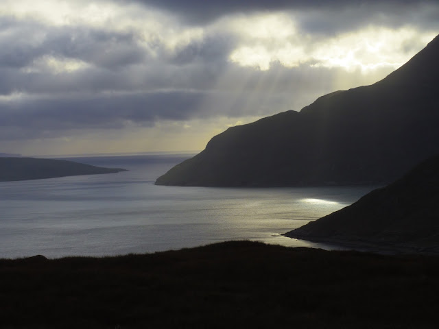
It was worth it. We ditched the bikes at the ridge, and headed down on foot, accompanied by a stunning light show as the sun poked out from behind the racing clouds. 

This is the view from the bothy, Camisunary, which lies right on the coast, in a huge glacial valley, at the foot of the dramatic Cuillen Hills. That night we shared the bothy with a young chap named Harry. He had hiked, alone, over the Cuillens that day, in complete cloud cover, rain, and strong wind. Poor chap. For dinner, we made a surprisingly tasty pasta carbonara alla kipper! 

Yep, that's the bothy. In the morning, we decided to spend a second night there, so embarked on a hike in the Cuillens. We walked right along the coast on a path round the nearest headland. After warming up, we went for a quick dip in the ocean, then sunned ourselves dry (although it was perhaps a bit cold for that - some pushups were involved). 
The Cuillens are spectacularly beautiful with 1000m+ peaks rising straight out of the ocean, and we were blessed with the perfect weather. The day before, Harry saw none of this! For someone who loves mountains, and loves the sea, this was heaven. After our successful hike, we returned to the bothy, read on the beach, and collected driftwood for the fire. That afternoon, a friday, a constant stream of people arrived at the bothy. Some were forced to camp outside, but spent the evening inside. In total, there were 18 or so people -- now we realized why this bothy was described as "popular." Fair enough, the views are worth it! We spent the evening chatting and drinking other people's whisky, after claiming pole position in front of the fire. A different sort of bothy experience, for sure
The following morning, we hiked out, then got back on the bikes and finished the last of our food - two pieces of salami each. We then headed north, stocked up on food in Broadford, then looped around to the western coast of Skye. After a night there, we headed back east to Portree, then north to a campsite near Staffin. This was the only time we paid for accommodation in the 3 week trip. After a relaxing evening which included *gasp* a shower, the next morning we rose early and biked unloaded to the foot of the Quiraing.

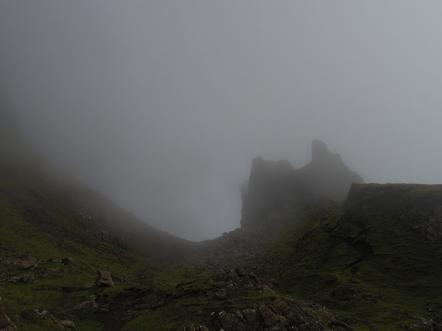
The Quiraing are on the left of this photo...hidden in the mist. They are a series of around 20 grotesquely shaped volcanic rock towers, which in fact were well suited by the misty, mysterious atmosphere. We clambered around for 45 minutes before bombing back down to our campsite, packing up, and heading south. 
 INTERLUDE:

We had a few day's left of our planned 3 week trip, and had run out of Skye. Instead of continuing to the Outer Hebrides, we decided to head inland to the Highlands to finish off our trip. So, from Staffin, we biked all the way down Skye over the course of 24 hours, a distance which had taken us almost a week on the way up. Mind you, the previous time we had taken just about every detour possible, and spent two nights at Camisunary. Unfortunately, the northerly wind which we had been cycling against for two weeks chose this exact moment to turn southerly, so we still had a headwind! Nevertheless, the weather was just beautiful, and with views to match. We took the ferry back to Mallaig, then hung out for several hours before catching a train to Rannoch Station, one of the more desolate train stations in the UK.

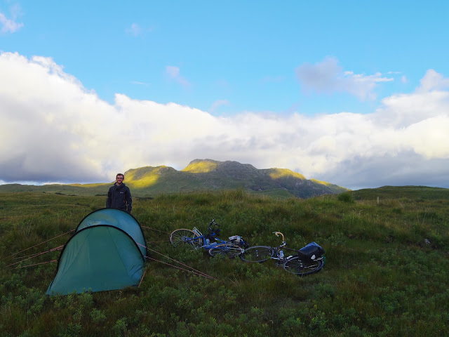
We left Rannoch Station and rolled less than a mile downhill to a beautiful highland campsite.
 The following day was actually one of the best day's cycling of the trip. We had a tailwind, and sun, and the roads were almost devoid of cars -- which in contrast to the rather busy roads of the islands was fantastic. I didn't take very many photos that day, perhaps I was too busy enjoying life! The day encompassed loch-side riding, river-side riding, and two long climbs. We camped at the top of the second one, an exposed site next to the small Loch na Lairige. The strong wind meant for perhaps the first night's camping -- no midges!


The following morning we gave up our plan of climbing the 1200m Ben Lawers, as the cloud ceiling was too low. Instead we headed up the ridge on the other side of our camp, which was a much more modest peak, and mostly below the clouds so at times we did have views better than that shown above. Back at camp, we picked and ate delicious bilberries (a relative of blueberries)
 The ridge was, however, incredibly windy. Check out Will playing in the wind below.


After our hike, we had a roaring descent down to Loch Tay, and then biked along the loch for the afternoon. We lucked out and found this spectacular loch-side campsite, simply by following an unmarked but promising dirt track towards the loch. Ben Lawers is visible across the loch, just above Will's head. Our previous night's campsite is in the notch to the left of Ben Lawers.
The following morning we woke to rain, and a distinct chill in the air. We breakfasted and read in the tent until 11am before accepting that the rain would not stop. So we packed up and headed out. With driving rain and steady wind, we were soon very cold, but we had to do a minimum of 30 miles that day in order to make our train back at Rannoch Station the following day. We ate a shivering lunch at a bus shelter, jumping up and down, pretend boxing, and generally acting foolish in order to keep what little warmth we had left. We finally reached the long climb up to the shoulder of Schiehallion, and I can say I have never been so relieved to start up a big hill. We had both been fantasizing all day about how warm it would be! We camped on the other side of Schehallion, in an old quarry next to the road, and had a surprisingly tasty dinner of pasta with leek and creme fraiche. The following morning we cycled back to Rannoch station, made sandwiches in the station's visitor center, then hopped on a train back to Glasgow.

Overall, a superb trip with a good balance of hard days, easy days, lazy mornings, bothies, midge-management, views, swims, climbs, descents and strange food concoctions! It was also great to spend so much time with Will. We have known each other for about a decade, but there is nothing like spending 24 hours a day within 5 feet of someone for weeks on end to make sure you really do want to be friends with them!

Fin 

Wednesday, October 28, 2015

The Other Side of Bolivia: The Lowlands Part 1

This past week, for our final group excursion, we headed east to the department of Santa Cruz. It is easy to think of Bolivia as an Andean country - all of the national government is located in the Andes, the two largest indigenous groups are Andean in origin, and until now we had spent all our time there. But, in reality, only one third of the country is located in this mountainous region, and the rest is tropical Amazonia and the dry Chaco. So it makes sense that for our longest trip we would descend to the hot, humid region of Santa Cruz, where life is entirely different.

For the first two days, we lived with families in a small Chiquitano community, six hours from the big city of Santa Cruz. The Chiquitanos are one of the larger original indigenous groups in the area. We lived in groups of two or three because the town was hosting the Plurinational Games while we were there, so many people were very busy with that. Basically kids from ten different schools descend upon the village and compete in various sports such as soccer, volleyball and running for five days. It was quite a scene!
Here is the "house" where Lex and I slept. It is really the weaving space of our host mom, Mercedes, but they hung up hammocks for us inside to sleep in. And much better to be in a structure that lets the air through - the breeze was the only thing that provided any relief from the hot, sticky air!

I really enjoyed cooking with Mercedes and learning the traditional techniques that people there use. The kitchen is simple: a covered outdoor space with a small table, a fire spot and, the most used implement, the taku, which is basically a giant mortar and pestle used to mash meat, banana, yucca, rice, etc. 
Here is Mercedes with the taku. The first night we ate majadito, which is rice with shredded charque - a dried piece of beef that is boiled and then mashed in the taku. With boiled ripe bananas on the side. 

The cooking fire. A very simple and practical setup with three stones to hold the pot and wood pushed in gradually through the spaces in between. 

The next morning we ate masaco: boiled green bananas that are mashed and mixed with cheese (or more charque in our case because Lex, my fellow student, is lactose intolerant). It was delicious!
The banana mash in the taku. Because the bananas weren't ripe, the dish had a very mild flavor. 

We headed out to an area of cultivation after breakfast to harvest bananas and plant some crops. All the land is communally-held and everyone works together to cultivate crops and care for animals. They also started an agroforestry coffee project five years ago with help from the government, and everyone participates in the harvest and processing of the coffee beans. 
We hacked down a banana tree to harvest the hanging branch of bananas, then planted some corn:
And sugar cane:
We also got to suck on a few pieces of cane, which was delicous! It's hard to beat that natural sweet juice coming straight out of plant!
Their other crops include yucca, sweet potato and lots of fruit trees! Too bad the mangoes weren't quite ripe yet. 
In the afternoon, after a lunch of freshly-killed duck, we headed to the pond to cool off. Unfortunately we started sweating again the second we got out! Then we prepared the ingredients to make rice bread the next morning. For this we had to grind soaked rice in the taku and push it through a mesh screen to make flour:
Then we peeled, boiled and mashed yucca, to be added to the rice flour. 
The next morning, we headed to our neighbor's house to use her oven to bake the bread:
Mercedes had mixed all the ingredients together: rice flour, yucca, salt, water, oil and lots of cheese. There's really only one kind of cheese here in Bolivia, that has a bit of a sour flavor. I was really into for a while, but I kind of overdosed on it after a month or two!
Scooping out the batter onto pans lined with banana leaves - instead of greasing the pan I think. Though the bread was incredibly oily so I can't imagine it sticking to anything! It was tasty, though very heavy for an already hot morning. We made trays and trays but I could only eat three! 
We spent our last few hours learning how to weave on the hanging loom that Mercedes uses:
The weaving is another initiative that began a few years ago to provide an economic opportunity to the women in the community. They make hammocks, bags and shawls mostly. In this photo, the thread has been naturally dyed with plants from the village. There are beautiful blues, purples, pinks, oranges and browns. It was fun to try our hand at the process and see how much care and practice it takes to make a tight, even weave!
The small section that Lex and I did. It would take two full days for Mercedes to complete this whole length!
She also showed me how she makes her own thread from cotton that the community cultivates. 
First, a process similar to carding wool, but using a bow of sorts to fluff the cotton. 

Then using a tool like a drop spindle, held between the toes, to spin the fibers into thread.

Even though this community visit was a bit short to really get a sense of the people and lifestyle, I enjoyed the time that we spent there. And I hope to try making some of the meals at home! Guess I'll have to carve a taku first!


Friday, October 23, 2015

Iceland in Photos

For those who believe a picture is worth a thousand words, or for the illiterate. A bunch of photos of Iceland, including many that didn't make the cut for the day-by-day trip report.


Get Adobe Flash player
Photo Gallery by QuickGallery.com

Monday, October 19, 2015

Bike Touring Iceland: The end days

Day 9: Snaefellsjokull to Stykkisholmur (by bike and bus)
Day 10: Stykkisholmur to Reykjavik Airport (by bus)

Our plan for the end of the trip was to ride the north coast of the Snaefell peninsula to the largish town of Stykkisholmur, from whence we would take a bus to Reykjavik and then to the airport. However, when we were forced to turn back by the snow, the need to cycle around the base of Snaefellsjokull added about 50km to the distance to Stykkisholmur. We could have cycled the full distance, but it would have left us only one bus option to make our flights, and the buses have limited, unreservable, bike spaces. Consequently, we decided to take a bus for part of the route along the north coast as well, taking the pressure off entirely.

We slept and snoozed and breakfasted before emerging from the tent at around 11am. Back on the road, we decided to take a 15km detour to visit Ondverdarnes, the westernmost point in Iceland. Since Postyn and I have both done the Camino de Santiago which ends at Finisterre, the westernmost point in continental Europe. Ondverdarnes makes the claim of being the westernmost point in Europe, but actually, being so far west as to be on the North American continental plate, we weren't so sure! We had a strong headwind and the dirt road was heavily washboarded, making the riding unpleasant. The spot itself was nothing special, although there were cool lava rock formations. Some water-smoothed boulders were hundreds of feet from the water, meaning the place must get some serious storms! There, I discovered that my left-front pannier rack had broken -- sheared off where it bolts to the drop-out. So I removed that rack and pannier and strapped them on elsewhere.
Ondverdarnes -- the westernmost point in Europe? 

From there we cycled along to Hellisandur, which had a bus stop and a tiny shop. We bought lunch foods there. After the previous night's horror of a meal, we splashed out on such luxuries as pesto -- even though prices were high, maybe 50% more than in Reykjavik. We caught the bus soon after, and had a beautiful drive to Stykkisholmur, although it felt a shame to race through the beautiful landscape in a bus, rather than savoring it by bike. But most people who visit Iceland hardly get out of their vehicles. We arrived in late afternoon, shopped for food and then headed down to the harbor to make dinner, sans cooking. We had a delicious canned bean/ salsa/ veggie salad, topped with crushed tortilla chips. Our meal was very drawn out as we had a long talk with the FGS -- friendly German stranger.

Lighthouse at Stykkisholmur harbor, photo by Postyn
In any case it was tasty, and our mood was jovial. We played "lettuce chicken." We had bought a head of lettuce which turned out included the plant's roots in a tiny pot of soil. It didn't fit in our salad bowl (our one cook pot) so we ate it in bites on the side. We took turns taking bites to see who would give up first. I think it was me -- i didn't really enjoy the taste of dirt on my lettuce. We also coined several fun phrases, such as "cuddle my tuft" and "chafing my moorings." Their meaning is unclear, but the words "Well, cuddle my tuft!" were said, along with "That really chafed my moorings."

We biked out of town a ways to find a spot to camp, and had a beautiful sunset.

Sunset over the mountains on the north coast of the Snaefell Peninsula. Photo by Postyn, from his sleeping bag!
In the morning, we woke early in order to be first at the bus stop, knowing that the spots available for bikes were first-come-first-served. We were very early, so checked out the town campsite, and found next to the trash, lots of fuel canisters, including one with some fuel left, which we took. As we approached Reykjavik, it began to rain. On the bus ride, we figured out expenses for the trip. Including everything spent from landing to taking off, we spent an average of $23 per day. A chunk of this was spent on buses, but still, food was expensive in Iceland.


In Reykjavik, it was pouring. We ended up taking another bus into the center of town because it was available for free with our ticket to Reykjavik. We spent the afternoon at the Harpa Center, the big concert hall. We ate outside under the cover of one of it's overhangs, and then read and relaxed inside for many hours. The weather was wild: driving winds and heavy rain. As the weather improved, we headed out to buy postcards and check out a cool 3d map of Iceland at the town hall. We then went to the bus stop to catch a 4:00 bus to the airport, the last of the day. Because I had to leave very early the next day, there was no way to get there in time, with our bikes. When the bus arrived, the driver looked at our bikes and said -- you can't bring those. Gulp. Turns out the route to the airport is the only one in the whole country on which Iceland's bus company, Straetó, does not take bikes. We biked back to the tourist office and asked about options. They didn't know anything, but checked online the schedule of the private bus company we had taken on the way in -- and said we had just missed the last one. Thankfully, Postyn decided to check on his phone, and in fact there was another one at 8pm. We called and were told we could just get tickets on the bus, and that our bikes were no problem. We thus had another 4 hours to kill at the Harpa Center!

Lunch under the glass façade of the Harpa Center

When the bus arrived, the driver had switched to a smaller van because he had very few reservations. Thankfully he was very kind and managed to squeeze our bikes into the van -- but if any other passengers had tried to get on, there wouldn't have been space! We got to the airport just after 9:00, to find the floors littered with young people waiting, as we were, for early morning flights. Signs in the airport said "no cooking or camping on the premises." I guess its a common problem. We headed to the far end of the parking lot to cook dinner. Our fuel ran out again, but thankfully our pasta was almost cooked. At around 10:30pm, in strong wind and rain, we cycled 100m outside the gates of the airport, pushed our bikes a ways into the grass to the shelter of an earth mound, and pitched the tent. We were quite damp, and the planes overhead kept us awake for several hours. We woke up at 3:30, in the dark, not very well rested, packed up, and pushed our bikes cross-country to the Bila-hotel where we had paid to store our bike box. Although open 24 hours, it took a while to find the right guy, and we then had to search four different rooms of bags to find our box. It took until just before 5am to sort our gear and disassemble my bike. Postyn left his intact, as he planned to cycle to a nearby hot-spring for the morning, before his afternoon flight!

Heading to the airport check-in, I found an empty check-in station and used it to balance the weight of my hand luggage, bike box, and checked bag, as I knew I was within a kilo of my max allowable weight. I then got in line to check in for WOW airlines. It was terrible. At the beginning, there were only two staff to check in two flights, and so I spent nearly an hour in line. Postyn meanwhile made me breakfast and a pack lunch -- what a boss. With 45 min to departure, I had to race with my bike box to oversized luggage, where there was another line. After a hurried goodbye to Postyn, I ran upstairs to find yet another line, for security. Through that, I ran straight to my gate (of course, the farthest one in the whole airport) and got there, sweating, with 2 minutes before the gate closed. On the plane I went straight to the toilets to change out of my gross clothes, then spent the 3 hour flight talking to the woman next to me, a American doing a biology Phd at Cambridge. She was from the Adirondacks, and, amazingly, had just been to a wedding in Williamstown! Small world.

And that concludes an excellent adventure in Iceland! We explored only a very small corner of the country, and I would definitely go back!


Saturday, October 17, 2015

Bike Touring Iceland: Day 8

Lysahúll to Mt. Snaefell

The snowy slopes of Snaefellsjokull (photo by Postyn)

We got an earlyish start as we knew we had a big day ahead. We continued along the coast, stopping mid-morning at a beach where we had heard we could see seals. Indeed there were about a dozen seals on the rocks and in the water. On land they are ungainly oafs, in water, completely transformed.


The seals are the not-quite-rock-color lumps among the rock-colored lumps
We continued on to the little town of Arnastapi, known for its lava sea cliffs. We didn't know what to expect, but it was wild.

Organ Pipes and crashing waves at Arnastapi
There were numerous rock arches

Including this one. Photo taken by a nice English couple touring Iceland in their camper van
Arnastapi sits at the foot of Mt. Snaefell, a 1500m volcano that forms the Westernmost part of the eponymous peninsula, along which we had been cycling for the last few days. We knew we probably wouldn't be able to summit it, as it is heavily glaciated, but wanted to hike at least part way up. We headed up the dirt road leading to the shoulder of the peak, planning on hiking from the summit of the pass, then descending down the north side of the pass to get to a town, food, and a bus back to Reykjavik. We began climbing the dirt road, and it was immediately hard. Parts too steep to ride. But views gradually improving to spectacular levels. 

Nice view
Nicer view
 As we reached the shoulder, the winds increased and the temps dropped. Snaefellsjokull was shrouded in cloud -- we couldn't see the summit. However, looking up we got occasional views of a spur of rock a good ways up, visible in the center of the photo below.

The summit is on the right of the photo, hidden in cloud. Our goal was the rocky outcrop in the center.


At the summit of the pass, we stopped for a late lunch. Then we ditched the bikes and packed layers, food and water into our backpacks, and headed up. We initially stayed on the lines of exposed rock which run upwards. When these ran out, we walked on the snow. On the way up, the views got even better. We could see the route we had cycled over previous days, giving an excellent new perspective at the end of the trip. Lucy and I did something similar last summer in Norway, with a hike on our penultimate day.


Boom. This is why we like mountains.

Higher. The clouds were whipping along the side of the mountain, alternately revealing and exposing the view over the course several seconds. Photo by Postyn.
After an hour and a half or so, we came to the base of the rocky outcrop which had been our target. Climbing this was tricky as the loose volcanic scree slid with every step.

The summit was very windy, and cold enough to be partly covered in rime ice, in August. On the way up we knew we were walking on glacial ice because beneath the snow it was bright blue, and there were occasional cracks -- the beginnings of crevasses. These can be seen in the photo above, as thin lines in the snow.

Buffeted by wind on our "summit," I had to keep one hand on my head to stop my hat blowing off! Excuse my finger in the image; mittens and wide-angle-lens-selfies don't go well together.
Looking upwards, the ridge was exposed and began to look more crevassed. We decided to turn back. After working our way slowly down the volcanic scree of our summit outcrop, we regained the snow. In a stroke of absolute genius, Postyn suggested we glissade (French for "slide on your a$$") back down. This was brilliant fun, and we descended in 15 minutes what took us almost two hours to climb.

`
 After our outrageously fun descent -- a highlight of the trip -- we repacked our bikes and continued along the road. It was about 4:30 pm by this point. We had thought we were at the summit of the pass and thus were looking forward to a long descent. However, around the bend, the road continued upwards. Soon we came to a patch of snow covering the road, and had to dismount. This happened several times before we arrived, relieved, at the actual pass. Unfortunately, when we looked down the other side, all we could see was snow, disappearing into the clouds.

While there had been little snow on the way up, we now realized we were looking at the north-facing slope --considerably snowier. And we had been told earlier that this had been a record snow year for Iceland. 8m in some places. But still, a pass of this altitude closed in August? There were faint car tracks through the snow, so we set off on foot to see if we could follow them to the other side of the snow patch.However, the visibility was extremely poor. Without our own footprints to follow back, it would have been very easy to get lost.  In all, we spent an hour following various tracks across the snow, including a faint set of bicycle tires. We still hadn't found the other edge of the snow, and it was 6:30pm. We didn't fancy a night on the snow, so returned to the bikes, and headed back the way we came.

Faint tire tracks visible during a brief break in the cloud cover. The spike on the skyline at the right of the image is where we climbed. Photo is Postyn's
We were disappointed to have to turn back, but also concerned that we were almost out of food, and would have quite a way to go the next day before reaching the next town with food. However, the descent was stunning. The views were the same as on the way up, but we were facing the right direction this time. It ranks as one of the best descents of my life, but I was certainly thankful for my fat mountain bike tires and disc brakes. Postyn enjoyed the descent less than I did, particularly as he had a small crash on the way down.

 Once down, I noticed a sign at the base of the road saying "impassable." Whoops. But it was a grand adventure in any case!

Concerned to make some distance before camping, we kept riding. Postyn led at a tough pace. I struggled to keep up, and by 9:00, after probably 12 hours on the move, was ready to camp anywhere. Unfortunately, we were passing through Snaefell National Park, where camping is forbidden, and in any case the land on both sides was nearly bare lava. Around 9:30 we found a spot to camp, with the summit of Snaefellsjokull cloud free and still in the sun above us.

Campsite at the foot of Snaefellsjokull. Photo by Postyn.
For better or worse, our adventurous day was not yet over. We were almost out of food. We still had breakfast food. But for dinner, all we had was several packets of quick-cook rice, a sprinkling of couscous, bouillon cubes, butter and a whole onion. Also, our trusty fuel canister finally sounded just about empty when shook. Whoops. We decided to cook everything at the same time to minimize the chance that the fuel would run out part way through. Unfortunately, after 5 minutes, it did run out. Our onions were basically raw, and the rice was very crunchy. We were very hungry, so started eating. As it turns out, Postyn and I both hate raw onion, so after a few bites forced down, we started picking out the onion. On the plus side, the couscous was cooked, but on the minus side, the raw rice and overpowering onion flavor were disgusting.

How fitting of Iceland that one of the best day's adventure of my life ended with the worst meal of my life.