Posts in English

To read the blog in English, click here.

Posts en español

Para leer el blog en español, haz clic aquí.

Wednesday, January 20, 2016

Returning to Cochabamba, by way of the Salar

Good news, everyone! We have a new tent! The director of my study abroad program returned to Cochabamba on Monday and brought with her the tent that we had sent to her in the US. We managed to get back to Cochabamba on the same day, spent a morning seam sealing it, and now are ready to take off on the next leg of our Bolivia tour!

In the end, we decided to travel from Tupiza to Cochabamba mostly by bus. We did buy a 3x3m tarp in Tupiza, but it was really more of an emergency shelter, as we weren't entirely confident that it would protect us from the strong winds and rain of the altiplano. 
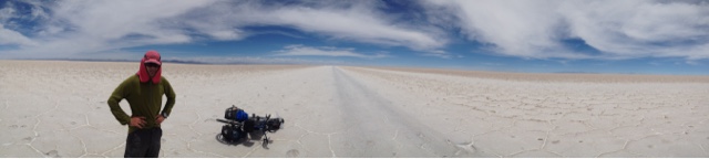
Nevertheless, we wanted to take advantage of the fact that our route would take us right past the Salar de Uyuni, the largest salt flat of Bolivia, so we wanted to be prepared to camp. On Tuesday evening we loaded our bikes on top of a bus and set off for Uyuni!
     Watching nervously during the bike loading process. 

Arriving at 3am in an unfamiliar city is never particularly enjoyable, though we'd done it once before in Sweden!, but we climbed on our bikes and set off in search of a hostel. We found one with a space after a few laps around the bus arrival area and soon collapsed into bed. 
The next morning, when I (Lucy) went to get my spoon to eat a breakfast watermelon, I discovered that it was no longer in my handlebar bag! Immediately distraught, I searched all my bags, but it, like the tent, was gone. Though I'd managed to keep it together when we lost the tent, somehow the disappearance of my spoon tipped me over the edge. The little world that we are trying to create for ourselves on the road felt like it was crumbling around us, and I felt my will to go on sapping out of me. I said in the last post that losing our tent was like losing our home, but until losing my spoon too, I hadn't really grasped the emotional toll that that would have on me. Our trip had started to feel very purposeless - taking buses and staying in hostels isn't what we came here for! And though we could be biking and camping with our tarp, the insecurity of traveling without a trustworthy shelter made that option not very attractive. 

Despite the emotional challenges, we had come to Uyuni to see the Salar and we couldn't miss it! So we set off on our bikes at about midday in search of salt. After about 25km on a flat, paved road, we reached the so-called entrance to the Salar!

Of course, this actually meant that we had about 10km on bumpy dirt or gravel with a strong headwind before actually reaching the salt flat. 
   Even on dirt, the landscape was incredibly flat and open!

We made it to what we thought was the Salar, but it turned out not to be what we were expecting! For one, it wasn't white! And though all the cycle tourist blogs we'd read raved about how flat and smooth the salt was, we actually found it to be more like bad, bumpy, cracked pavement. 
       One of the many sections covered with lots of tiny bumps!

We rode a few kilometers but, given that it was already late afternoon, decided to turn back and camp on the dirt. Rather than returning to the entrance town to stay in a hostel, we wanted to test out the tarp to see what it was capable of. 

The tarp stood up to the strong altiplano wind pretty well, though we were lucky it didn't rain! The next morning we set off toward the Volcano Thunupa on the other side of the Salar, which we thought to be about 80-90km away. Our main lesson of the morning was that riding on the Salar is, frankly, very boring. With the sun beating down above and reflecting up from below, an endlessly flat, never-changing view, and continual hexagonal cracks making the riding always a bit rough, by 25km we were doubting whether we could actually bear to make it to the other side. 
      Adie found his best bored riding position!

But a friend had strongly recommended visiting the volcano, so, after a deliberative snack break, we decided to push on. 
       Can't we just be there already?!

In the end, the volcano was worth the boredom of riding on the Salar. We slept in a hostel built of salt, then hiked up to about 4400m the next day on the volcano. Both the views down to the Salar and up to the colorful crater were incredible.
     Adie's back was not used to carrying a backpack!

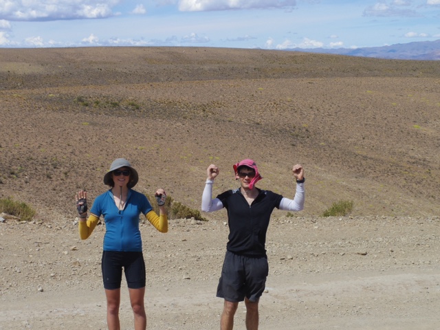
 And, we happened to run into someone I knew from Cochabamba while on the hike, who later passed us again while we were riding that afternoon! She took the following photo, a rarity with both of us in it...

After the day hike, we headed back out to the salt and crossed to the Isla Incahuasi. It is one of the major tourist stops, and was crowded with jeeps when we got there!
       Everyone hanging out at the salt beach. 

 After buying our entrance tickets, we cycled around to the back side and found a somewhat secluded spot to pitch the tarp. Unfortunately the wind changed direction during the night, so we endured a lot of tarp flapping, but overall it was a fairly successful night of camping. 

The following morning, we set out for our final day on the Salar, woohoo! We were very much ready for a change of scenery. There are very few times/places when we think it would be better to be traveling in a car, but the Salar was definitely one of them. It is just too big and monotonous for bikes. A day might be okay, but 200km was too much. We survived the last morning by telling stories to each other, one story from every year of our lives. We only got to about age 8, but it occupied us for quite a few hours! 

Transitioning from the Salar back to washboard managed to make me wish for the salt, but soon we reached pavement and were able to breathe a sigh of relief! We headed back to Uyuni, planning to catch one of the very infrequent trains that was to pass through that night. We discovered that the ticket office wasn't going to open until 11pm, so we chilled outside the station all afternoon. After cooking dinner, we discovered the waiting room had been opened, so we moved our stuff inside to wait the last few hours. Unfortunately, upon doing so, we noticed a board with ticket availability that was covered with the word "agotado"- sold out! No! All that waiting, only to find out there wasn't any space left on the train. Dejected, we rushed over to the bus area to see if there was anything we could catch to Oruro. Luckily, there was a bus leaving ten minutes later. We hurriedly consolidated our belongings, then shoved our bikes into a bottom compartment and hopped on. Unfortunately, in the chaos, we left Adie's Platypus water bag at the train station...yet another item lost for good.

We arrived in Ouruo at 2:30am and biked to the house of a couple that I had met during one of my  trips with the study abroad program. They were gracious enough to take us in at 3am, give us a bed, and feed us delicious food the next day. We left the bikes with them when we went to Cochabamba to pick up the tent, and now are back at their house readying ourselves for a two-week trip before coming back to experience Carnaval. 

Our plan is to head west to Chile over the next few days, cross the border at Pisiga, then head north through some Chilean national parks before crossing back at Tambo Quemado. It is an area of volcanoes and lots of geothermal activity. We are looking forward to (hopefully) celebrating Lucy's birthday in a hot spring! Then we will check out the highest mountain in Bolivia, the volcano Sajama, 6500ish meters, before finishing the loop back to Oruro. We are very excited to be getting out on the road again!

Sunday, January 17, 2016

De Tarija a Tupiza

Jueves, 5 de enero


Empezamos temprano, saliendo de la casa de nuestro anfitrión a las 7:30. Después de desayunar en la calle, salimos de Tarija. Las bicis sentían muy pesadas. Manejamos hacia San Lorenzo. Era interesante porque habíamos hecho la misma ruta algunas días antes con nuestro anfitrión y su club del ciclismo. 

San Lorenzo con ciclistas tarijeños

Es raro pedalear por la misma ruta sin peso y con peso, y nos hizo dar cuenta de la diferencia entre manejar con todo el equipaje, aunque era asfaltado y más o menos plano! Antes de llegar a San Lorenzo, doblamos a la carretera a Potosí. El primer 25km era plano, pero Adie se pinchó. 


Llanta parchada, empezamos a subir. Nuestra velocidad era 5-6kph, y no cambió, por seis horas. La subida nos pareció eterna. A la una, nos sentimos cansados y nos dolían los músculos. Nos sentamos al lado de la calle, Adie casi durmiendo en su asiento de campamento. Pero comimos chocolate y pichamos un poco de coca, antes de compartir masajes de pierna muy dolorosas. 


Pronto, pareció como si estuviéramos cerca a la cumbre. Pero, al llegar a la "cumbre" nos dimos cuenta de que solo era una mesa y, después, la subida continuó. Podíamos ver zig-zags de la calle subiendo una montaña, antes de desaparecer, probablemente en el túnel de lo que habíamos oído. 


Después de unos zig-zagas, la velocidad de Lucy empezó a bajar. Poco después, paró y escupó su coca, diciendo "necesito azúcar! Nunca en mi vida he querido azúcar como esto!" Es chistoso porque por todo la semana y el semestre, Lucy había pensado que mucha de la comida y las bebidas aquí eran demasiados dulces. Por ejemplo, se conoce Tarija por su vino, pero todo es muy, muy dulce. Pero de dulces, solo teníamos unos kiwis, higo seco y un poco de chocolate amargo. No estábamos pensando en dulces cuando compramos comida! No nos acordamos el azúcar de maple que la mamá de Lucy nos había dado. Lucy dijo que finalmente pudo comprender porque a los cicloturistas les gustan Snickers (algo Adie ha sabido desde su viaje en bici en Francia y España en 2011).


Continuamos, intentando pensar en la vista y no en nuestras piernas. Podíamos ver todo lo que habíamos subido, incluyendo el valle de Tarija. Una vez, un cóndor enorme voló cerca, flotando en el aire adelante de nosotros. Lo vimos como señal de buena suerte; sí podíamos terminar la subida! 


 Y sí, terminamos, a las 4:00 de la tarde, después de 6 horas y 1600 metros de subir. Fue la subida más larga de nuestras vidas. 


También, encontramos un arroyo para llenar nuestras botellas, antes de entrar al túnel. Desafortunadamente, al otro lado, descubrimos que habíamos olvidado uno de las botellas allá, así Adie tuvo que volver para recogerlo. 


Bajamos, buscando lugar para acampar. Después de una noche nerviosa durante nuestra viaje de prueba cerca de Cochabamba, decidimos que, en áreas pobladas, sería mejor pedir permiso de alguien para acampar. Entonces, con un poco de ansiedad, paramos en la primera casa y preguntamos a una mujer si había buen lugar cerca. Después de un poco de confusión, ella dijo, "adentro" y nos mostró un cuarto que se estaba construyendo. Tenía piso de piedra, pero ofreció protección del viento y la lluvia. Le agradecimos y estábamos desempacando cuando entró llevando un colchón y mantas. Después, cuando ella vió nuestra estufita, nos ofreció el uso de su cocina para cocinar la cena! La cena fue un plato nuevo para nosotros, inspirado por nuestro anfitrión en Tarija: harina de maíz con queso y verduras. 


Miércoles, 6 de enero

En la mañana cocinamos avena, pero todavía no recordamos el azúcar de maple! Salimos y, pronto, salimos de la carretera. Manejamos en un valle largo por una calle asfaltada y tranquila.


Después de unos kilómetros, la calle cambió a tierra. También empezamos a subir otra vez. Subiendo en una calle de tierra es muy lento y había más y más tráfico. Muchos vehículos tenían banderas bolivianas, y nos dimos cuenta de que estaban en ruta a ver el Dakar, que estaba pasando por Villazón/Uyuni. 


Después del almuerzo, terminamos la subida, llegando a la altura de 3600m, y encontramos la oficina de guardaparques del Parque National de Sama. Sabíamos que el parque estaba cerca pero no sabíamos los detalles. Paramos para pedir agua y los guardabosques nos dijeron que había lagos con varios tipos de aves, dunas de arena, etc. Descendimos hasta los lagos y doblamos antes del primero, pensando en pasar la tarde paseando por los lagos antes de llegar otra vez a la carretera. El valle era impresionante, largo y plano con montañas a todos lados. 


Vimos muchos pájaros, pero no vimos flamencos (según los guardabosques, hay). Continuamos alrededor del lago, y la ruta empeoró y no era tan plano que habíamos pensado. 

Eventualmente nos dimos cuenta de que teníamos que acampar. Buscamos la primera casa, pero no había gente. Continuamos al pueblo cerca, pero pareció casi abandonado. Por fin, encontramos una abuelita, pero era ciega y sorda! Seguimos buscando y encontramos todo el pueblo, en la iglesia. Era el 6 de enero, último día de Navidad, y habíamos llegado durante la misa! Cocinamos la cena y miramos el relámpago sobre las montañas al otro lado del valle. Después de la misa recibimos permiso para acampar al lado de un edificio municipal.


Jueves, 7 de enero

Continuamos nuestro circuito de los lagos, parando para jugar en las dunas.


Después de cruzar el valle, bajando a una altura de unos 3200m, empezamos a subir, en tierra de baja calidad. Por suerte, cuando volvimos a la carretera, era asfaltada! Pero después de un rato, la asfalta desapareció. Después de la cumbre (3800m), bajamos al pueblo de Yunchará. Había un poco de lluvia, y almorzamos en un comedor. Afuera de Yunchará, estuvimos muy sorprendidos por encontrar una bajada enorme en un gran valle!


El descenso duraba 25km....


Pero mas importante, bajamos a 2600m, perdiendo 1200m de subida durísima! Era como nunca habíamos visto antes. 

Al fin de la bajada, había un pueblo, Tojo, donde llenamos todos nuestras botellas de agua, porque alguien nos dijó que al otro lado del valle había una subida "igualito" a la bajada. No! Esto es el problema cuando no tienes mapas topográficos...nunca sabes como va a ser la ruta. 

Viernes, 8 de enero

En la mañana, tratamos de empezar temprano, pero Lucy descubrió que se había pinchado su llanta. Esto es un problema de acampar entre cactus! 


Empezamos a subir a las 7:30, y subimos unos cientos de metros, antes de descubrir otra bajada! Después, la ruta siguió un río por unos 20km, entonces no empezamos la verdadera subida hasta las 9:00. 


Por suerte, la subida era menos pendiente y tenía menos curvas que la bajada del día antes. Continuamos a ver muchos autos con banderas y adhesivos de Dakar, pero este día, volviendo a Tarija. La subida era larga y caliente y fuimos de 2600m a 3400m, antes de llegar a una cumbre...el altiplano! 


El altiplano pareció muy plano después de nuestros días en las montañas. Nos descansamos y filtramos agua en la sombra de un árbol, la primera sombra que habíamos visto en horas. Después, tomamos la carretera (asfaltada) hacia Tupiza. 


Seguimos una tormenta eléctrica en la distancia. No sabíamos la distancia a Tupiza, pero imaginamos que había unos pueblos en la ruta. Lo que no imaginamos era encontrar una bajada enorme! Otra vez! Noooo! Era divertido descender en ruta asfaltada -- hicimos 70kph -- 10 veces más rápido que nuestra velocidad promedia de los últimos días. Pero bajamos mucho, casi hasta la altura de Tojo, donde habíamos empezado el día. 


En un pueblo después de la bajada, paramos en la plaza para botar nuestra basura, que incluyó uno de los Crocs de Adie - había perdido el otro sin darse cuenta durante la subida. También consultamos nuestro mapa y pareció que Tupiza no estaba en el altiplano como pensamos, sino en el valle. Con la distancia que habíamos hecho durante el decenso, nos faltaron solo 25km más a Tupiza. Aunque ya eran las 5:00, decidimos tratar de llegar, el sueño de una ducha motivándonos!


Había un viento adelante, y más cerros que esperamos, y era 30km no 25, pero llegamos por fin, agotados y sudorosos, a las 7:15pm. Encontramos un hotel, con baño privado (para lavar la ropa en paz) y cenamos, antes de acostarnos. Este día: 12 horas, 110km y 1000 metros de subida en bici. 

En total de Tarija: 280km, la mitad asfaltada, la mitad de tierra, tres subidas enormes, la altura máxima de 3800m. Y pensábamos que la aventura solo iba a empezar en Tupiza!

De Tupiza, teníamos planes de ir por el árido Sur Lipez, a San Pedro de Atacama, en Chile, un viaje de 8-10 días. Pero, planes cambian! Por casualidad, llegamos a Tupiza con el Rally Dakar! No sabíamos, pero casi todo el pueblo de Tupiza estaba en la calle, mirando los autos de Dakar pasar por la ciudad. La tarde después de llegar a Tupiza, íbamos a salir en el camino a San Vicente. Cuando encontramos la ruta, también encontramos el Dakar; el rally vino por nuestra ruta a San Vicente! Entonces tuvimos  que pasar una segunda noche en Tupiza. 

Pasamos la tarde mirando el Dakar con toda la gente, pero la gente también estaba mirando a nosotros: estos gringos en bicis con todo su equipaje. Mientras manejamos por las calles, gente gritaba "Dakar, Dakar." Cuando Adie los saludó con la mano y hizo sonido de claxon, como todos los camionetas, todo la gente aclamó! Nunca hemos estado tan populares!


Tuesday, January 12, 2016

Missing: One Beloved Tent

Yep, that's right. Our tent is gone. And when you're living on the road, losing your tent feels like losing your house. In our case, the house was two painstakingly hand-sewn tents made by Adie, the inner for our first bike trip two and a half years ago, the outer specially for this trip. 
Unfortunately, we have little to no hope of it turning up at this point (the story of the search is below) so we are back in Tupiza, where we have just ordered a new tent. The director of my study abroad program is returning to Bolivia this weekend from her holidays in the US and has generously agreed to bring the tent back with her! So our plans have changed, but we will only be tent-less for a week! We just have to get back to Cochabamba somehow to pick it up. And we will be without Adie's wonderful handcrafted house forever. 

So, the story. We set out from Tupiza early Sunday morning, expecting to be on mostly empty roads for 8-10 days until reaching Chile. We spent the next eight hours slowly and painfully climbing 1300 meters on a beat-up dirt road to reach what we thought would be the altiplano. But, our main lesson from the first week of riding is that Bolivia is very rarely flat, even when it's called a plain! So the view of the other side from the top revealed a sweeping descent to a dry riverbed, with steep mountains and valleys all around!
     Amazing rock surrounded us the whole way up!

     We made it to 4,000 meters! (That wasn't the end though...)

     One small section of the winding road. 

Given that it was already nearly five o'clock, we set off down the other side, hoping to find a protected camping spot in the river valley below. The road down was in even worse condition than the way up, with deep sandy ruts carved in every curve and loose rocks pretty much everywhere else! We found happiness in the fact that we were going down and not up it! If only we knew what was to come...

      The inevitable descent!

Upon reaching the bottom, we found a tiny community of llama farmers. The family that owned the one little shop kindly offered us space in their patio to camp for the night. Apparently they've had other bike tourists and backpackers sleep there before! We gratefully accepted and went to set up the tent, which is when we discovered that it was no longer strapped to Adie's bike! Our stomachs instantly dropped. Unfortunately, the tent had been strapped under Adie's saddle, in exactly the spot where he had lost a croc two days before... I guess we didn't learn our lesson. We searched the family's property, but it was nowhere to be found. Knowing that we had seen it at the top of the road when we put our helmets on for the descent, we decided we would have to go back and search for it along the 6km descent. All of a sudden, the wonderfully peaceful, empty road became a nightmare, as we realized that probably no cars would pass that might be able to give us a ride to the top. 

So, we set off on foot. One ambulance passed, but it was carrying a patient so it had no room for us. We walked and walked and walked, searching over both edges, fueled only by the hope that the tent would be waiting for us around the next bend. Somehow, the altitude of 3800-4300meters didn't even affect us! We just kept pushing on, feeling unable to turn back as it would mean giving up hope, even as we watched lightning storms fill the sky around us. 

At about 3/4s of the way up, Adie decided to take off running, while I kept walking because of my weak hamstring. After a few minutes I was finally able to catch a ride in the back of the truck, which carried me to meet Adie just starting down from the summit. No tent. Shell-shocked and exhausted, we began to hurry back down as darkness fell around us, hoping to hitch a ride and make it to the bottom before the storms hit us. 
Unfortunately, the bountiful generosity we have received here did not extend to the drivers that night. Only 3 or 4 cars passed us, but they were either full or didn't even bother stopping. Disheartened, we continued on, watching lightning strike closer and closer. When it became blinding, striking the ground right in front of us, we took of running, to hell with the hamstring! At nearly the same moment, drops started to fall, which quickly turned into a driving mix of rain and hail. We ran blindly down the hill, the road instantly becoming a sandy river and the light of our headlamps barely making a difference. Finally, after 2km of running, we saw a light ahead and new that we had made it. We stumbled into the store, through the flooded patio, and into a bare room where the family had kindly moved our bikes. They said it was nearly impossible because of how heavy they were! They stood watching as we fixed a bed in the corner, then brought in a bowl of soup for us to share. Once again, I was left feeling utterly overwhelmed with gratitude for their care and hospitality. What crazy, ridiculous gringoes they must think we are!

We quickly dropped off to sleep, but woke with the sinking feeling that it was not all a dream, which the soreness in our bodies was quick to prove! We slowly packed up while considering our options, but knew that the only thing we could do was go back the way we had come. All that work, and we would just have to go back down! But first, we had to go back up, retracing the 6km for the fourth time, and probably the hardest time yet. Exhausted and sore, we eventually made it up to the top for the last time, still finding no tent. We then headed down the other side, which was a very uncomfortable 2 1/2 hour descent!

      Struggling back up. 

Now, back in Tupiza, we are thinking of heading to the Salar de Uyuni to see the salt on our way to collect the tent in Cochabamba. We will probably use a combination of bikes/trains/buses to get back. It has been a rough few days, but the experience has taught us humility in many ways. And we will never leave anything not securely attached to the bikes ever again!

      If we're in a city, we might as well eat fruit!

Saturday, January 9, 2016

Tarija to Tupiza

 Tuesday, January 5th


We got an early start, leaving our host's house at 7:30. On the streets of Tarija, our bikes felt ungainly, overloaded. On the way out of town we pulled over at a roadside food cart and ate a big cooked breakfast. We then biked north towards San Lorenzo. This was interesting mostly because we had ridden this section already, on Sunday, with our host and about 10 other Tarijan cyclists. 

San Lorenzo with Tarijan cyclists

It's rare to ride the same ride loaded and unloaded, and really brought home the difference the weight makes, even on relatively flat, paved road. Short of San Lorenzo, we turned off on the main road to Potosí, the nearest big city, perhaps 500km away. We spent the rest of the day on this road. The first 20 or 25km were flat and uneventful, except that Adie got a flat. Even with good touring tires, nails are nails, and there was one embedded in the tire. 


Flat fixed we soon began climbing. Our speed dropped to 5-6kph (3-4mph), and then pretty much stayed there, for hours. The climb seemed to go on and on. By about 1pm we were both really starting to feel it. Muscles tight, threatening cramp, eyes drooping. We sat down by the side of the road. Adie was practically falling asleep in his camp chair in the drainage culvert, but we ate some cocoa and some coca, and then traded painful deep-tissue calf massages before getting on the bikes again.


Soon, it seemed like we were reaching the crest of the climb. However, once over the top, we could see the road stretching out before us. First we faced a flatish section on a sort of plateau, but then the road began zigzagging up the face of a steep mountain. High above, the road disappeared; the tunnel we had been told about, presumably. 


After a few switchbacks, Lucy was beginning to slow. Finally she pulled over, spat out her cheekful of coca, and said "I need sugar! I've never wanted sugar so badly in my life!" This was particularly funny because all week (all semester?) Lucy has found much of the food and drink to be way too sweet. For example, Tarija is known as Bolivia's wine region, but all the wines we have tried have been absurdly sweet. Even the not-sweet wines are sweeter than any desert wine you would find in the US. So we dug around for some sugar, and found kiwis, dried figs, and a small amount of dark chocolate. I guess we weren't thinking sugar when we food-shopped! (Only the next day did we remember that we were carrying maple sugar sent by Lucy's mom...doh). Lucy made the astounding comment that she now understood the appeal of snickers bars to bike tourists (Something Adie has known since touring in France/Spain in 2011).


We pressed on, trying to remain distracted by the views, which stretched all the way down to the valley floor where Tarija is located. On one zig, an enormous condor flew by quite close, and then hovered above us on the thermals. Lucy pointed out that the condor is a sacred bird in Andean culture, so seeing one was good luck; we would make it to the top of the climb!


 And indeed we did, at around 4:00pm, after 6 hours and 1600m of ascent. This made it the longest climb either of us have done, by a good margin. 


We also found a little stream to refill water, before cycling through the tunnel, just under 1.5km long. Unfortunately, at the other side, when we stopped for a snack, we realized we had left a water bottle behind, so Adie went back. 


We then cruised downhill, looking for a place to camp. After a nervous night wild-camping on our test trip near Cocha, we decided that in populated areas, it would be better to ask someone where we can camp. So with some hesitancy we walked our bikes past some llamas into the yard of a small farm where a woman was standing with her daughter. We asked whether there was somewhere we could camp, and after some confusion about tent, etc, she pointed to one of the small buildings forming the perimeter of the yard, and said, "a dentro," inside. The room was under construction, with a rough stone floor, but it had a roof, and was out of the wind. We were very grateful. As we unpacked, the woman reappeared with mattresses and blankets! Then, when she saw our little stove, she offered us the use of her kitchen. We made a camping meal new to us (from a tip given by our Tarija warmshowers host), polenta with cheese and veggies. 


Wednesday, January 6th

In the morning we made oatmeal, but still hadn't remembered the maple sugar. We then hit the road, leaving the highway soon after. We headed down a long valley on a very quite paved road. 


However, all good things must end, and after a few km, the asphalt did. We also began climbing, regaining the altitude we had lost since the tunnel. Climbing on rough dirt is slow work, and the traffic began to increase. Many of the vehicles had Bolivian flags flying, and we realized they must be heading towards the Villazon/Uyuni area to watch the Paris-Dakar Rally (which is in Argentina and Bolivia this year, funnily enough.


After lunch we reached the top of the climb, at about 3600m and there found a National Parks guard house. We knew we would pass through a national park on this road, but didn't know anything about the park itself. We stopped in to ask for water, and were given it, but also asked if we had registered for entry. We hadn't but were able to there and then. They explained that the park contained salt lakes which were a haven for dozens of species of birds, including flamingos, that there were sand dunes etc. We descended down towards the lakes, then turned off before the first, planning on spending the afternoon riding around the far side of the lakes before rejoining the main road. This valley was impressive, long and flat bottomed, surrounded my mountains.


We saw many birds, but none of them were flamingoes. As we continued around the lakes, the road deteriorated, and was hillier than expected. 


Eventually we realized we would have to stop for the night. We poked around the first house we came to, and although it looked very lived-in, there was no-one around. We continued on to the next little hamlet, and walked around. Again, lived-in but no people around. Eventually we found an old woman, but she was deaf and blind, so we had no luck asking about camping. Eventually we found some people, lots of people, at the church. It was January 6th, the last day of Christmas, and we happened to turn up during mass! We waited til mass was over, watching a thunderstorm over the mountains opposite, then camped in front of a municipal building. During the night a dog started barking at us, and continued barking for hours! 


Thursday, January 7th

We continued on our loop around the lakes, heading for the main road but we also stopped to play in some sand dunes!


After crossing the valley, dropping to perhaps 3200m, we began climbing, on bad quality dirt. On rejoining the main road we were relieved to find it paved! As the climb continued, the asphalt ended. We snacked then continued climbing, with great views back across the valley. Past the summit (3800m), we quickly descended to the town of Yunchara. There we waited out some rain, and had a big lunch at a comedor. As we continued out of town, we were astounded to find ourselves at the head of an enormous canyon-like valley, with a switch backing descent stretching out endlessly in front of us. 

The descent was 25km long...

But more importantly, we dropped all they way down to 2600m, some 1200hard-earned meters!
This was unlike anything we have ever seen before, nevermind cycled!

At the bottom was a town, Tojo, where we filled water, lots of it, because we were told that on the other side of the valley, we would be climbing right back up again. Oh no! This is the problem with not having topographic maps...you just have no idea of what's ahead!


We camped in a dry riverbed on the other side of town, just at the start of the climb. The tent was pitched in a tight spot hemmed in by cacti and other very thorny plants.

Friday, January 8th

In the morning we tried to get an early start so as to start climbing before the day's heat began. We were delayed, however, by Lucy's discovery that she had a flat. That's the problem with thorny campsites! At the same time we also attempted to patch a developing side-wall rip in Lucy's front tire. 
We began climbing at 7:30, and climbed a couple hundred meters, before finding in front of us even more descent! The road then followed a river for about 20k on decent first, so that we didn't start the climb until 10am or so.


The ascent was less winding and perhaps a bit less steep than the descent, for which we were greatful. We continued seeing cars with Dakar stickers and flags, but this time returning back to Tarija. 

The climb was long and hot, and we went from about 2600m to 3400m, before cresting a ridge and having a strong suspicion that we had reached the altiplano! 


As the road continued, our ridge joined what was clearly the altiplano. It seemed very flat, after our days in the mountains. We rested and filtered water in the only shade we had seen for hours, under a tree, before joining the (paved) caretera! 


We followed a distant thunderstorm northwards, heading to Tupiza. We weren't sure how far it was on the highway, but expected some towns in between. What we didn't expect was an enormous descent....nooooo! We did enjoy the paved descent, hitting 70kph at one point, about 10x faster than we had been going the last few days! We found ourselves back at 2800m, almost whee we had started the day.


 At one of the towns down in the valley, we stopped in that plaza and got rid of our garbage, which included one of Adie's Crocs. The other had fallen off the bike, unnoticed at some point during the climb, and we certainly weren't going back for it! We also consulted our map, and it seemed Tupiza was not on the altiplano as we had thought, but further along the same river valley. Combined with the distance we had covered descending, we realized that although it was already 5pm, we could probably make the 25k to Tupiza before dark, and spend the night in a hotel! Adie was concerned the hotels would be full because of Dakar, but we decided to go for it. 

There was a headwind, and more hills than we expected, and it was also more like 30k, but we made it, exhausted and sweaty, at 7:15pm. We booked into the first hotel we found, a bit pricy, but with private bathrooms meaning we could do our laundry. We got dinner then forced ourselves to do laundry before collapsing in bed, after almost 12h, 110km, and 1000 vertical meters of cycling!

 In total from Tarija, 280km, half paved, half dirt, three big climbs, max altitude 3800m. And we thought getting to Tupiza was just the bit before the adventure started! 

From here, we had planned to head into the barren Southwest, to Chile and San Pedro de Atacama, which we expect to take 8-10 days. However, plans change! We spent the morning food shopping and looking unsuccessfully for wifi, but the town felt very empty. Most of the stalls in the market were closed, very odd for a weekend. We thought it might have to do with the 12th day of Christmas. Nope. Around 2pm today, we were cycling out of town, and found all the people of Tupiza thronged around the river. As we pulled up, we saw an off-road racing car tearing up the riverbed. Turns out the Dakar Rally is passing through Tupiza today. What's more, the route the cars (and motorbikes, ATVs, and full-on trucks) took to arrive in Tupiza was exactly the road we plan to ride! Since the road would be closed til evening, we decided to stay another night here.

 We hung around town, watching the trucks pass through town (now not in the river bed because recent rain meant rising water levels) and became somewhat of a spectacle ourselves. Lots (dozens) of people wanted to take photos with us. As we biked through town, Adie waved and "honked" as the truck drivers had been doing, which drew cheers from the thronged spectators. 

So here we are in Tupiza another night, at a different hotel, this time with wifi. And tomorrow we leave for real.